


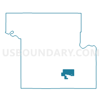
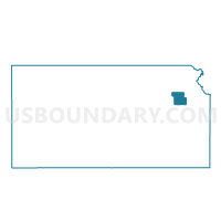
Montara Voting District, Shawnee County, Kansas
About
Outline

Summary
| Unique Area Identifier | 587157 |
| Name | Montara Voting District |
| County | Shawnee County |
| State | Kansas |
| Area (square miles) | 7.21 |
| Land Area (square miles) | 7.18 |
| Water Area (square miles) | 0.03 |
| % of Land Area | 99.58 |
| % of Water Area | 0.42 |
| Latitude of the Internal Point | 38.94329250 |
| Longtitude of the Internal Point | -95.66633800 |
Maps

Graphs
Select a template below for downloading or customizing gragh for Montara Voting District, Shawnee County, Kansas


Neighbors
Neighoring Voting District (by Name) Neighboring Voting District on the Map
- Cullen Voting District, Shawnee County, KS
- Northwest Monmouth Voting District, Shawnee County, KS
- Pauline Voting District, Shawnee County, KS
- South Monmouth Voting District, Shawnee County, KS
- Topeka Ward 12 Precinct 12, Shawnee County, KS
- Topeka Ward 6 Precinct 10, Shawnee County, KS
- Wakrausa Voting District, Shawnee County, KS
Top 10 Neighboring County Subdivision (by Population) Neighboring County Subdivision on the Map
- Topeka city, Shawnee County, KS (127,473)
- Williamsport township, Shawnee County, KS (4,000)
- Monmouth township, Shawnee County, KS (3,021)
- Topeka township, Shawnee County, KS (917)
Top 10 Neighboring Place (by Population) Neighboring Place on the Map
Top 10 Neighboring Unified School District (by Population) Neighboring Unified School District on the Map
- Auburn-Washburn Unified School District 437, KS (34,191)
- Shawnee Heights Unified School District 450, KS (19,057)